At the top of the world, there is a sea—the remains of one, at least. The summit rocks of Mount Everest, the highest elevation on Earth, contain fossils of trilobites, arthropods, and other denizens of the ancient Tethys Ocean, which once separated the landmasses that are now Asia and the Indian subcontinent.
Today these sea creatures are entombed 8,849 meters (29,032 feet) above sea level. At that elevation, Mount Everest scrapes the jet stream; winds of well over 160 kilometers (100 miles) per hour are common, and temperatures can regularly dip below −30°C (−22°F). Oxygen levels are just one third of what they are at sea level, putting Everest’s summit in the “death zone” where most organisms (including humans) cannot survive for more than a short time.
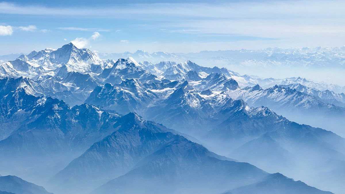
The fossilized marine organisms that crown Everest have been along for one of the most visibly dramatic geologic rides of the past 60 million years: a reshaping of Earth’s crust that produced the highest mountain range on the planet. The Himalayas include 10 of the world’s 14 “eight thousanders,” the peaks higher than 8,000 meters (26,247 feet), including Kangchenjunga, K2, and, rising above all of them, Everest (also known as Chomolungma or Sagarmatha).
How sediments that once sat under an ocean came to form the roof of the world is a question that has puzzled geologists for more than a century. Expeditions to the high Himalayas to retrieve rock samples and map visible faults, paired with analytical techniques such as seismic profiling and low-temperature thermochronology, have revealed Everest’s internal structure and hinted at how millions of years of tectonic movement have caused it to grow.
Today, scientists have a good picture of the forces that have worked both to push up and bring down Everest. But many questions remain, including when the mountain reached such great heights, whether the rocks that built it were warm and flowy rather than brittle, and how long the world’s highest peak will hold its crown.
Making a Mass of Mountains
Scientists trace the beginnings of Everest and the modern Himalayas to a fated collision that began between 50 million and 60 million years ago. For about 80 million years after breaking from the ancient supercontinent Pangaea, the Indian tectonic plate raced northward before ploughing into the southern edge of Central Asia.
Exactly when the collision started is still debated, but the earliest stratigraphic evidence for it is provided by 59-million-year-old nanofossils and reworked zircons from the Eurasian plate that show up in Indian plate sediments. Evidence from marine sediments puts the final closure of the Tethys Ocean much later, around 34 million years ago.
At that time, the Tibetan Plateau was already a land of mountains. Earlier convergence between the Eurasian plate and oceanic crust underlying the Tethys would have built mountains with a chain of volcanoes, though it’s not clear exactly how high and how far north that mountainous region extended. Today the 4,000- to 5,000-meter-high (13,100– to 16,400-foot-high) Tibetan Plateau covers 2.5 million square kilometers (965,000 square miles) north of the Himalayas.
Some studies using oxygen isotopes, which glean paleoaltimetry data from the composition of rainwater that once fell on the surface, indicate the region may have been 3.5 kilometers (2.2 miles) above sea level as far back as 60 million years ago.
Other oxygen isotopic evidence shows that the plateau likely rose later and that the Himalayas could have looked something like they do today 40 million years ago, said John Cottle, a geologist at the University of California, Santa Barbara. Some researchers go even further and argue that the plateau reached its modern elevation only within the past 15 million years.
Regardless of the exact timing, the elevated plateau set the stage for creating the roof of the world, but another colossal geological event was needed for the modern Himalayas to rise.
A continent-on-continent collision is akin to an unstoppable force meeting an immovable object—in this case, the force being the Indian plate and the object being Asia. The base of the Indian plate rammed underneath Asia while its upper sedimentary layers wrinkled and folded on top of themselves like snow piling against a moving shovel. The force of the collision compressed and shortened the Indian plate by as much as 900 kilometers (560 miles), pushing the landscape to towering heights.
The Himalayas today sit just south of the suture, the surface boundary between the still-colliding tectonic plates. Everest itself is near the middle of the range, straddling the border between Nepal and China’s Tibet Autonomous Region.
We still don’t know when Everest took shape as a mountain peak. The rocks from which it is assembled range from tens of millions to hundreds of millions of years old, and many have been metamorphosed by the high temperatures and pressures involved in the collision between the Indian and Asian plates. Some evidence as to when the mountain emerged comes from its tip: The limestone at its summit records evidence of light deformation around 40–45 million years ago, followed by a period of rapid cooling around 35 million years ago, an indication that it was shallowly buried and then pushed to the surface, said Kyle Larson, a structural geologist at the University of British Columbia. That pattern could place an upper limit on the peak’s age.
One study using oxygen isotope paleoaltimetry measurements indicates that Everest was already 5,000 meters (16,400 feet) high by the early Miocene, between 23 million and 16 million years ago. However, this estimate is speculative, as the technique may not be very accurate, said Matt Kohn, a metamorphic petrologist at Boise State University.
How Everest, and not another nearby Himalayan peak, got to be the highest mountain in the world is probably “just luck,” Larson said. “There’s nothing specifically special about Everest.”
Inside Everest

If we could peer inside the Himalayas, we would find a sequence of squished and buried rocks scraped off the Indian plate, separated by faults that slice through much of the crust. These faults all stem from the Main Himalayan Thrust (MHT), along which the Indian plate is still sliding beneath Asia. Each split off the MHT over millions of years as successive layers of material stacked up. The faults all generally dip just slightly to the north and intersect the surface south of Everest, giving geologists a tilted view of the layers that make up the mountain.
At the bottom, deep beneath Everest, are the highly metamorphosed gneisses and granitic rocks of the Indian shield, part of an Archean craton that underlies the subcontinent.
The MHT, which is nearly horizontal, separates these basement rocks from a stack of deformed layers above, each of which contains a different chapter in the tale of collision and mountain building. Older, structurally higher segments of the MHT are now inactive; the Main Frontal Thrust (MFT) is the currently active arm of the MHT. It emerges at the surface far south of Everest, where it thrusts sedimentary rocks of the Siwalik Group, which eroded from the Himalayas to the south into a basin beginning 15 million years ago, over young sediments forming today.
The Siwalik sediments are capped by the Main Boundary Thrust (MBT), which was active around 5 million years ago (though some estimates put this as early as 14 million years ago). Above the MBT are the lightly metamorphosed sediments of the Lesser Himalayan Sequence (LHS) exposed in the lowlands of India, Nepal, and Bhutan. These metamorphosed marine sediments were deposited on the edge of the Indian plate beginning almost 2 billion years ago and have been scraped off and folded by a series of stacked faults that lifted the layers above them.
The Main Central Thrust (MCT), which was active from around 25 million to 13 million years ago, separates the LHS from the Greater Himalayan Sequence (GHS) above. This tens-of-kilometers-thick sequence of highly metamorphosed rocks contains gneisses, as well as pockets of leucogranites formed by partial melting.
The GHS makes up the bulk of Everest and most major Himalayan peaks. Its features are indicative of the titanic forces that have uplifted the range.
Many of the GHS rocks began as sediments deposited in the Precambrian era, more than 540 million years ago, but most of the metamorphism began around 40 million years ago and continued to 15 million years ago. That intense period of metamorphism shows when compressive forces, and perhaps crustal thickening and uplift, were strongest, said Mike Searle, a structural geologist at the University of Oxford.
Above the GHS are more metamorphic rocks topped by the roughly 160-meter-thick (525-foot-thick) Yellow Band, a well-known layer of marble that signals to climbers the summit is near.
At the very top of Everest, beginning at around 8,600 meters, are limestones and other sedimentary and metasedimentary rocks of the Tethys Ocean. The Tethyan rocks are generally younger than rocks of the GHS, though younger leucogranites in the GHS are evidence that that layer was pushed in millions of years after the Tethyan rocks were emplaced. Debate about how and when this happened has yet to be resolved.
“The structures in the Himalayas were the first time people realized that you could get lowangle normal faults in a compressional tectonic environment.”
Strikingly visible on the mountain’s sheer southwest face, the South Tibetan Detachment System (STDS) separates the GHS from the Tethyan sediments that cap the mountain. Elsewhere in the Himalayas, the STDS is one main fault. However, in Everest it consists of two strands: the lower Lhotse Detachment and the upper Qomolangma Detachment. These faults were likely active at the same time as the MCT, indicating that all three faults are linked.
The STDS is a normal-sense fault that is oriented nearly horizontally, a distinct oddity in a landscape dominated by thrust faults. Along the STDS (and its strands), the rocks of the GHS moved to the south and upward. So-called detachment faults like this are typically found in places where the crust is being stretched and thinned, such as in the U.S. Basin and Range Province, Searle said.
“The structures in the Himalayas were the first time people realized that you could get low-angle normal faults in a compressional tectonic environment,” he said.
Did It Flow, or Did It Wedge?
How a type of fault known to facilitate crustal thinning came to be found at the top of the world’s highest mountain is a long-standing, unsolved problem. In the late 1990s and early 2000s, researchers began describing two distinct hypotheses to decipher it.
One model, known as channel flow, is based on evidence of deformation and metamorphism from the rocks of the GHS in Everest’s deep innards and the MCT and STDS faults that bound them. Leucogranites formed when parts of the Indian plate were partially melted after being pushed deep under Asia and heated, suggesting that the GHS was warm and capable of flowing. Pressed between hard Tethyan rocks above and hard LHS rocks below, the viscous rocks of the GHS flowed outward along the Himalayan range front beginning around 25 million years ago, helped along by strong erosional processes removing material as it was pushed to the surface.
“It’s like squeezing a tube of toothpaste and then taking a cap off the toothpaste,” Larson explained.
Another model, known as critical wedge, presents a different story. Its proponents suggest that within the LHS and GHS, thrust faults repeatedly pushed rocks on top of one another. The duplexing, or stacking of layers, seen in the LHS is consistent with this model, Kohn said, as is evidence that metamorphic rocks in the GHS get progressively younger and less metamorphosed deeper down.
“We don’t really have a very clear idea of what are the fault orientations when they go in the subsurface.”
“What you end up with is [the idea that] these rocks under[neath] were transported the least distance into the orogen and the rocks up on top came from the deepest parts of the orogen,” he said.
Both the channel flow and critical wedge models involve the rocks of the GHS being pushed up and to the south beneath the Tethyan sediments, which would necessitate the normal-sense STDS on top and a thrust fault (the MCT) on the bottom, as seen within Everest. Unlike along other normal faults, the rocks above the STDS did not slide down so much as the GHS moved up while Tethyan rocks sat passively above them.
Decisive evidence favoring one theory over the other has yet to emerge, in part because obtaining high-quality data from underneath the Himalayas is challenging. “We don’t really have a very clear idea of what are the fault orientations when they go in the subsurface,” said Malay Mukul, a geologist at the Indian Institute of Technology Bombay. “That’s a big knowledge gap.”
Many agree that each model likely explains different aspects of the Himalayas, though to what degree isn’t settled. More recent work has suggested a kind of synthesis of the channel flow and critical wedge models, implying they may have worked in concert to build the Himalayas.
Most scientists, regardless of which theory they support, agree that the STDS and MCT became inactive by about 13 million years ago, though a few estimates using different dating methods give younger ages. Meanwhile, the MFT is still pushing the mountain upward.
Everest, Present and Future
While the collision between the Indian plate and Asia was working to push the Himalayas skyward, Everest and other peaks were being carved by rivers and glaciers into the silhouettes we see today.
“With things like the Indian monsoon, Earth is trying to tear [the Himalayas] down as fast as they’re being built.”
“With things like the Indian monsoon, Earth is trying to tear [the Himalayas] down as fast as they’re being built,” Larson said. “Because of the large-scale deformation that’s still ongoing, these [peaks] are able to still poke up and be anomalously high.”
Summer monsoons bring at least 300 centimeters (118 inches) of precipitation to parts of the south side of the Himalayan range crest each year. The northern Himalayas and the Tibetan Plateau are relatively dry.
This contrast means Everest is two-faced, experiencing a rain shadow effect with far more erosion happening on the south side and much less on the north.
Everest today stands atop the current high point of the Himalayan crest, which divides the southern lowlands from the Tibetan Plateau and bears the brunt of the erosion. What that means for the mountain’s future is uncertain, with opposing forces of tectonic uplift and surface erosion vying to determine the mountain’s height.
GPS measurements show the Himalayas are currently rising by roughly 2 millimeters (0.08 inch) per year, which fits with other evidence showing that the subduction and thickening of the Indian plate are still occurring.
Even more recent events may have given the mountain a boost. A 2024 study claimed the nearby Arun River swelled in size around 90,000 years ago, increasing erosion and leading to isostatic uplift, a process in which the crust rebounds as weight is removed. That process could have added a millimeter (0.04 inch) per year to Everest’s growth, the study’s authors said, though some scientists disagree with their conclusions, which are based on modeling.
Still, scientists widely agree that Everest continues to rise, though how long that might continue and how tall the mountain will get aren’t clear. The mountain may already have reached its limit, Cottle said. “The thickness of the crust that you need to support that elevation is probably already somewhat at a maximum,” he said. Any taller and the crust underneath may move or change, causing the mountain to sink down once again.
“I wouldn’t be surprised if Everest continues growing up and up and up.”
Searle, on the other hand, thinks the mountain may have room to grow. As long as the continental collision continues, he said, the Himalayas will rise. “I wouldn’t be surprised if Everest continues growing up and up and up.”
Further in the future, on the order of millions of years, movement on the MFT could stop, because thrust motion could shift to another part of the Indian plate to the south. That new thrust could form nearby, meaning the Himalayas may simply move a few tens of kilometers south, or it could happen much farther away.
Should that happen, the upward motion of the Himalayas would cease, leaving the mountains to be slowly ground down by erosion. Everest is a monument to the gravity-defying power of tectonics. But it is no match for wind, water, and, most of all, time.
Author Information
Nathaniel Scharping
Citation: Scharping, N. (2025), How to build the world’s highest mountain, Eos, 106, https://doi.org/10.1029/2025EO250061. Published on 13 February 2025.
Text © 2025. The authors. CC BY-NC-ND 3.0
Except where otherwise noted, images are subject to copyright. Any reuse without express permission from the copyright owner is prohibited.
Related
#Build #Worlds #Highest #Mountain